Introduction
gIQ is an end-to-end, AI-powered SaaS ecosystem designed to democratize analytics of geospatial data by enabling SMEs revolutionize geospatial analysis, commercialize their work, and make quick informed decisions based on powerful data insights.
The platform significantly transforms raw spatial data into actionable insights, empowering organizations to make smarter, data-driven decisions.
What is gIQ?
gIQ is a SaaS platform for geospatial intelligence, combining advanced AI/ML algorithms, interactive visualization tools, and a collaborative workspace environment. It supports the entire workflow of working with geospatial data—from acquiring imagery to analyzing, annotating, and publishing insights.
Whether you are an urban planner, environmental scientist, or GIS professional, gIQ enables you to:
- Unlock hidden patterns in massive datasets.
- Predict trends and future scenarios with machine learning models.
- Collaborate and share insights across your organization.
- Streamline workflows with customizable analysis pipelines.
Key Capabilities
-
Workspaces for Collaboration
Group layers and files in centralized hubs, share across teams, and export reports seamlessly. -
Data Acquisition
Order imagery from leading providers such as ICEYE and Sentinel-1, or access their archives and tasking requests. -
Visualization & Reporting
Create compelling visualizations and generate comprehensive reports to communicate findings effectively. -
Marketplace for AI & Applications
Host and commercialize AI models, applications, and reports, enabling knowledge exchange across organizations. -
3D Interactive Globe
Explore spatial datasets on an immersive, high-performance globe that integrates multiple data layers. -
Precise Annotation & Segmentation
Annotate raster files, perform object segmentation, and train AI models directly in the platform.
Who Can Use the gIQ Platform?
gIQ is more than a platform—it is an end-to-end ecosystem for modern geospatial intelligence.It is used and trusted by:
- Urban Planners – for smart city design and infrastructure planning.
- Environmental Scientists – for monitoring ecosystems and climate impacts.
- GIS Professionals – for spatial analysis, visualization, and reporting.
- Decision-Makers – for strategy, policy, and operational efficiency.
gIQ: Concept of Operations (CONOPS)
gIQ provides a modular, role-aware workspace for visualizing, acquiring, and processing geospatial data.
What You See Is What You Get: The modules you see in the interface depends on your platform version, role and the permissions assigned to your role.
Primary Modules
The primary modules are listed in the navigation sidebar:
| Navigation Sidebar | Primary Module | Sub-Module |
|---|---|---|
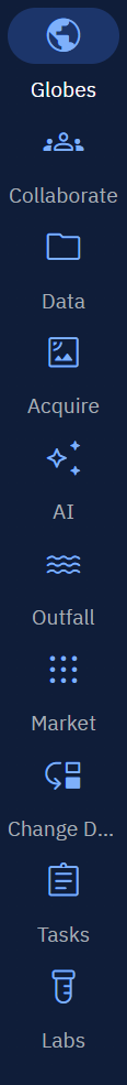 | Globe |
|
| Collaborate |
| |
| Data |
| |
| Acquire |
| |
| AI |
| |
| Market |
|
Admin & User Management Modules
These modules enable you to take control of the administration and user management of the platform. You can also view the documentation and notifications generated by the platform.
| Navigation Sidebar | Main Module | Sub-Module |
|---|---|---|
 | System Panel |
|
| Credits |
| |
| Reports |
| |
| Notifications | NA | |
| Upload | NA | |
| Help | NA | |
| Language | NA | |
| AI Assistant | NA | |
| Profile Avatar |
|