Overview: Acquire Module
The Acquire module enables you to buy imagery data from different vendors from the platform. The imagery data acquired from different vendors and satellite data providers can also managed from within the platform.
Depending on the roles and permissions, the acquisition and approval workflow is also monitored and tracked in the platform.
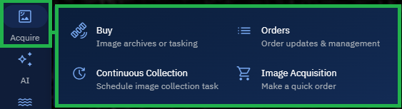
The Acquire module consists of the following sub-modules:
-
Buy: The Buy sub-module includes the following:
- Search Archive: Browse, evaluate, and purchase archive imagery from leading vendors through the platform.
- Tasking : Purchase future imagery that currently does not exist by directly commissioning satellite tasking through the platform.
-
Orders: View, monitor, and manage imagery orders and order details.
-
Continuous Collection: Set up recurring automated collection tasks (for a specified area) to acquire matching imagery as soon as it becomes available.
Supported vendors & data providers
The platform supports the following vendors and data providers for different types of data acquisition:
| Provider | Archive Order | Tasking | Continuous Collection |
|---|---|---|---|
| Airbus | ✅ | ✅ | ❌ |
| Black Sky | ✅ | ✅ | ❌ |
| Capella | ✅ | ✅ | ❌ |
| Landsat | ✅ | ❌ | ✅ |
| Maxar | ✅ | ❌ | ❌ |
| Planet | ✅ | ✅ | ❌ |
| SatVu | ✅ | ❌ | ❌ |
| Sentinel-1 | ✅ | ❌ | ✅ |
| Sentinel-2 | ✅ | ❌ | ✅ |
| Space42 | ✅ | ✅ | ❌ |
| Satellogic | ❌ | ✅ | ❌ |
Accessing Acquire Module
In this section, you will get to know how to access the Acquire module in the platform.
To access the Acquire module, do the following:
-
Login to the gIQ platform.
-
Click the Acquire module to access the sub-modules displayed:
Getting to know vendor supported imagery type, products, and other capabilities
Supported imagery type
Use this table to familiarize yourself with platform supported imagery types. You can select the vendor/provider and select the available options as displayed in the following table:
| Vendor/Provider | Panchromatic | Multispectral | SAR | Thermal | Stereo |
|---|---|---|---|---|---|
| Airbus | ❌ | ✅ | ❌ | ❌ | ❌ |
| Black Sky | ❌ | ✅ | ❌ | ❌ | ✅ |
| Capella | ❌ | ❌ | ✅ | ❌ | ❌ |
| Landsat | ❌ | ✅ | ❌ | ❌ | ❌ |
| Maxar | ✅ | ✅ | ❌ | ❌ | ❌ |
| Planet | ❌ | ✅ | ❌ | ❌ | ❌ |
| SatVu | ❌ | ❌ | ❌ | ✅ | ❌ |
| Sentinel - 1 | ❌ | ❌ | ✅ | ❌ | ❌ |
| Sentinel - 2 | ❌ | ✅ | ❌ | ❌ | ❌ |
| Space42 | ❌ | ❌ | ✅ | ❌ | ❌ |
| Satellogic | ❌ | ✅ | ❌ | ❌ | ❌ |
Vendor-wise options & clipping capabilities available
In this section, you get to know the various options you need to select depending on the satellite imagery vendor. Each vendor offers something unique and different from each other.
Search Archive
| Vendor | Selection 1 | Selection 2 | Selection 3 | Selection 4 | Selection 5 | Clipping |
|---|---|---|---|---|---|---|
| Airbus | Resolution 0.3m 0.5m 1.5m | Cloud Coverage 0-100% | Off-Nadir Angle 0-60 Degree | - | - | Yes |
| Black Sky | Product Daytime Nighttime Area 2*1 Burst 2-Frame Stereo 5-Frame Stereo | Cloud Coverage 0-100% | - | - | - | No |
| Capella | Collect Mode Spot Site Strip Polarization HH VV Either | Product Type CPHI CSI CSIDD GEC GEO SICD SIDD SLC VS Off-Nadir Angle 5-75 Degree | Orbital Plane Mid-Latitude 45° Mid-Latitude 53 SSO:97 Squint Angle 0-45 Degree | Orbit State Ascending Descending Either Slant Range Resolution 0.3-10m | Observation Direction Left Right Either Azimuth Resolution 0.5-11.5m | NA |
| Landsat | Cloud Coverage 0-100% | - | - | - | - | No |
| Maxar | Sensor GE01 WV01 WV02 WV03_VNIR LG01 LG02 WV04 | Cloud Coverage 0-99% | Ground Sample Distance 0-500cm | Off-Nadir Angle 0-60 Degree | - | Yes |
| Planet | Product SkySat Collect PlanetScope Scene | Cloud Coverage 0-100% | - | - | - | Yes |
| SatVu | - | - | - | - | - | No |
| Sentinel-1 | - | - | - | - | - | No |
| Sentinel-2 | Cloud Coverage 0-100% | - | - | - | - | No |
| Space42 | Product Spot Spot Fine Spot Extended Area Dwell Dwell Fine Dwell Precise Strip Scan | - | - | - | - | No |
Tasking
| Vendor | Selection 1 | Selection 2 | Selection 3 | Selection 4 | Selection 5 | Selection 6 | Selection 7 | Selection 8 | Selection 9 | Selection 10 | Drawing Tool |
|---|---|---|---|---|---|---|---|---|---|---|---|
| Airbus | Product 0.3m | License Type Standard Background Layer Standard+ Background | Cloud Coverage 10% 20% 30% | Incidence Angle 20-50Degree | - | - | - | - | - | - | Rectangle Polygon |
| Black Sky | Product Daytime Nighttime Area 2*1 Burst 2-Frame Stereo 5-Frame Stereo | Offering Elite Standard Preferred | License Type COM Internal COM Groupd 2-5 COM Group-5 COM Public Release ING Level-1 ING Level-2 ING Level-3 ING Level-4 | Withhold None 30 Days Permanent | - | - | - | - | - | - | Point Tool |
| Capella | Collection Type Spotlight Ultra Spotlight Spotlight Wide Stripmap 20 Stripmap 50 Stripmap 100 | Collection Tier Urgent Priority Standard Flexible | Collection Time Anytime Day Night | Incidence Angle 5-50Degree | Azimuth Angle 0-360Degree | Orbital Plane Mid-Latitude 45° Mid-Latitude 53 SSO:97 | Orbit State Ascending Descending Either | Observation Direction Left Right Either | Polarization HH VV Either | Archive Holdback None 30Days 1 Year Permanent | Rectangle Polygon |
| Planet | Product Flexible Tasking | Imaging Mode Single Stereo Tri-Stereo | Elevation Angle 60-90 Degree | - | - | - | - | - | - | - | Rectangle Polygon Point |
| Space42 | Product Spot Spot Fine Spot Extended Area Dwell Dwell Fine Dwell Precise Strip Scan | Incidence Angle 5-45Degree | Pass Direction Ascending Descending Any | Look Side Left Right Any | - | - | - | - | - | - | Point Tool |
| Satellogic | Product Multispectral-70cm | Priority Rush Priority Standard | - | - | - | - | - | - | - | - | Point Tool |
Understanding Vendor Product Types, Collection Mode, and Sensor List
In the section, you will get to know the all the products and applications presented by the satellite imagery vendors.
Product Types
Black Sky
| Product Type | Description | Use Case |
|---|---|---|
| Daytime | Visible light, Near Infrared (NIR) | Land use classification, vegetation health monitoring, urban planning, agricultural assessment |
| Nighttime | Thermal infrared, nighttime visible imagery | Urban light pollution studies, energy consumption analysis, disaster response (power outages), security monitoring |
| Area 2*1 | Area 2*1 refer to an area with specific dimensions, such as a grid or a region that covers 2 km by 1 km or 2° by 1° | Small area monitoring, targeted surveillance, local environmental studies, infrastructure inspection |
| Burst | Satellite's sensor captures a series of rapid, consecutive images or "bursts" of a specific area. These bursts are typically collected in short intervals, allowing the satellite to gather multiple data points over a targeted region in a quick sequence | Where rapid changes in the Earth's surface need to be monitored, or when observing fast-moving objects, like vehicles, ships, or even dynamic environmental conditions such as storms |
| 2-Frame Stereo | In 2-frame stereo, two separate images of the same area are taken from two different positions or angles. These frames are captured at the same time (or close to the same time) but from slightly different viewpoints, which allows for the generation of a stereo pair. By comparing the two images, it's possible to create a 3D view of the terrain | Basic 3D topography, terrain analysis, land cover mapping |
| 5-Frame Stereo | 5-frame stereo is a more advanced technique where five images of the same area are captured from five different angles or positions. This technique enhances the quality and accuracy of the stereo data and provides a denser, more detailed 3D model | Detailed 3D models, elevation mapping, dynamic terrain monitoring |
Capella
| Product Type | Description | Use Case |
|---|---|---|
| CPHD (Certified Product for Hydrography and Data) | Certified data for hydrographic surveys and water-related features. | Flood monitoring, water management, navigation |
| CSI(Cloud and Surface Interaction) | Data on the interaction between clouds and Earth's surface. | Weather prediction, climate studies, environmental analysis |
| CSIDD (Cloud and Surface Interaction with Data Derivation) | Derived data from cloud-surface interactions for studying surface conditions. | Agriculture, ecosystem monitoring, climate analysis |
| GEC (Geophysical Environmental Change) | Data that tracks geophysical environmental changes like land cover and climate. | Climate change monitoring, disaster response |
| GEO (Geostationary Earth Orbit) | Data from satellites in geostationary orbit, providing continuous Earth observation. | Weather monitoring, communications, environmental observation |
| SICD (Synthetic Aperture Radar Image Chip Data) | Format for storing SAR data, typically used in high-resolution radar imaging. | Earthquake monitoring, environmental monitoring, military surveillance |
| SIDD (SAR Instrument Data Delivery) | Raw data delivery from SAR instruments. | Radar remote sensing, displacement mapping, surveillance |
| SLC (Single Look Complex) | SAR data format with complex pixel information from a single radar pass. | Interferometry, topography, surface motion analysis |
| VS (Very Small) | Refers to very small pixels or features in satellite imagery. | High-resolution imaging for detecting small features |
Planet
| Product Type | Description | Use Case |
|---|---|---|
| SkySat Collect | High-resolution satellite imagery (50-72 cm) captured by Planet's SkySat constellation, providing both still imagery and video capabilities with rapid revisit times and off-nadir collection angles up to 25 degrees. | Urban planning and infrastructure monitoring, construction site progress tracking, disaster response and damage assessment, defense and intelligence applications, port and maritime activity monitoring, high-resolution change detection |
| PlanetScope Scene | Medium-resolution (3-5 m) multispectral imagery from Planet's Dove constellation, providing daily global coverage with 4-8 spectral bands including RGB and NIR for comprehensive Earth observation. | Agricultural crop monitoring and yield prediction, deforestation and forest management, large-scale environmental monitoring, land use and land cover classification, vegetation health assessment (NDVI), broad area change detection and temporal analysis |
Space42
| Product Type | Description | Use Case |
|---|---|---|
| Spot | High-resolution imagery of a small area. | Urban planning, infrastructure management, environmental monitoring. |
| Spot Fine | Higher-resolution imagery of a small area with fine details. | Detailed land-use analysis, precise infrastructure monitoring. |
| Spot Extended Area | Higher-resolution imagery of a larger area than standard spot products. | Regional land-use studies, environmental monitoring. |
| Dwell | Extended imaging over a specific area for a longer period. | Large-scale environmental monitoring, vegetation studies. |
| Dwell Fine | High-resolution extended imaging over an area for a longer period. | Precision agriculture, detailed land monitoring. |
| Dwell Precise | High-resolution, high-precision extended imaging over a specific area. | Engineering surveys, land subsidence detection, coastal erosion monitoring. |
| Strip | Narrow, elongated strip of imagery over a continuous area. | Monitoring transportation corridors, coastlines, or riverbanks. |
| Scan | Wide-area imagery captured with a scanning pattern. | Large-scale mapping, vegetation surveys, disaster management. |
Collection Mode
Capella
| Mode | Resolution | Area Covered | Use Case |
|---|---|---|---|
| Spotlight Ultra | 10-30 cm per pixel | Very small, focused area | Precision surveillance, military, detailed urban mapping |
| Spotlight | 0.5 - 1 meter per pixel | Small, defined area | Urban planning, agriculture, disaster monitoring |
| Spotlight Wide | 1 - 3 meters per pixel | Wider, but still focused area | Medium-scale urban/environmental monitoring, change detection |
| Stripmap 20 | 20 meters per pixel | Wider area coverage | Large-scale land monitoring, deforestation, infrastructure |
| Stripmap 50 | 50 meters per pixel | Wide area coverage | Regional environmental monitoring, large-scale surveying |
| Stripmap 100 | 100 meters per pixel | Very wide area coverage | Global-scale monitoring, climate studies, large-area reconnaissance |
Sensor List
MAXAR
| Sensor Type | Name | Resolution and bands |
|---|---|---|
| GE01 | GeoEye-1 Satellite Sensor | 0.50-meter panchromatic (B&W) and 1.84-meter multispectral |
| WV01 | WorldView-1 | 50 cm (panchromatic) |
| WV02 | WorldView-2 | 50 cm (panchromatic), 1.85 m (multispectral) |
| WV03_VNIR | WorldView-3 Visible and Near-Infrared | 31 cm (panchromatic), 1.24 m (multispectral, VNIR) |
| LG01 | Landsat 8 satellite's OLI (Operational Land Imager) | 30 meters (multispectral) OLI sensor captures data in 9 spectral bands |
| LG02 | Landsat 8 satellite's TIRS (Thermal Infrared Sensor) | 100 meters (thermal bands) |
| WV04 | WorldView-4 | 31 cm (panchromatic), 1.24 m (4-band multispectral) |